Posted: 26 December 2010 1007 hrs
WELLINGTON: A series of strong aftershocks rattled the New Zealand city of Christchurch Sunday, cutting electricity supplies, damaging buildings and forcing evacuations.
Although there were no reported injuries, parts of the central city were cordoned off as a precaution following one of the most damaging series of quakes since a 7.0 shake in early September caused widespread destruction.
The most powerful of the aftershocks was magnitude 4.9 on the Richter scale and 12 kilometres (7.5 miles) deep with its closeness to the city centre magnifying its impact.
"There have been larger aftershocks but they have tended to be around the city and have damaged usually in-ground infrastructure," said civil defence manager Jon Mitchell.
Christchurch city policy commander Derek Erasmus said there had been some damage to buildings in the inner city.
"As a precaution we have cordoned off two blocks ... until building inspectors have had an opportunity to assess the damage," he said.
About 40,000 houses had their electricity supplies cut for about an hour following the main shake.
Hundreds of shoppers taking advantage of the Boxing Day sales were temporarily evacuated from one of the city's largest malls where there was "superficial" damage, Mitchell said.
-AFP/wk
Sunday, December 26, 2010
Saturday, December 25, 2010
Tsunami hits Vanuatu on disaster anniversary
Posted: 26 December 2010 0840 hrs
SYDNEY: A powerful 7.3-magnitude earthquake struck off the western Pacific nation of Vanuatu on Sunday, triggering a small tsunami exactly six years after giant waves killed 220,000 people around the Indian Ocean.
The Hawaii-based Pacific Tsunami Warning Centre said the shallow quake generated a tsunami, but it cancelled a regional warning after the wave measured only 15 centimetres (six inches) higher than normal in Vanuatu.
"Sea level readings confirm that a tsunami was generated," the centre said in its bulletin.
"This tsunami may have been destructive along coastlines of the region near the earthquake epicentre," it said, but cancelled the warning when no destructive wave hit.
The quake struck at 12:16 am on Sunday (1316 GMT Saturday), and the initial tsunami warning covered Vanuatu, Fiji and the French Pacific territory of New Caledonia. There were no reports of damage or casualties.
Jackie Philip, a member of staff at the Melanesian Port Vila Hotel in the Vanuatu capital, said the hotel was busy with late-night Christmas revellers when the quake struck.
"Some of us, we ran outside and stood and watched the sea for a few minutes but nothing happened. There is no damage and no injuries," he said, adding that no tsunami warning had been given on local radio.
A receptionist at Port Vila's Grand Hotel called it a "small" earthquake, adding that calls to the meteorological office went unanswered. Staff at the nearby Island Magic Hotel also said there had been no local tsunami warning.
"We haven't had any notification of a tsunami," a worker told AFP. "We definitely felt the earthquake but we are notified if there's actually a tsunami."
Meteorological and disaster management officials were not available for comment when contacted by AFP.
The US Geological Survey said the quake was just 12.3 kilometres (7.6 miles) deep, and its epicentre was 145 kilometres (90 miles) west of Isangel, on the island of Tanna -- home to an active volcano -- in the Vanuatu archipelago.
The USGS revised its initial readings for the magnitude and distances involved, after first recording the quake at 7.6.
At least a dozen aftershocks of magnitude 5.0 or greater hit the area in the hours after the main tremor, according to USGS.
Vanuatu, which lies between Fiji and Australia and north of New Zealand, is part of the "Pacific Ring of Fire" -- an ocean-wide area alive with seismic and volcanic activity caused by the grinding of enormous tectonic plates.
Sunday's quake came on the sixth anniversary of one of the worst natural disasters of modern times, when a huge tsunami triggered by an undersea quake off Indonesia killed more than 220,000 people around the Indian Ocean.
After the disaster, which came with little or no warning for millions of coastal residents, regional governments deployed a string of monitoring buoys in the Indian and Pacific Oceans to keep track of any abnormal waves.
In August, a 7.5-magnitude earthquake off Vanuatu generated a small tsunami and sent thousands of frightened people running for the hills.
In September last year, Samoa in the Pacific suffered its worst natural disaster when three rapid-fire quakes of up to 8.1 magnitude unleashed waves as high as 15 metres (50 feet) that flattened villages and tourist resorts.
The seismic catastrophe claimed 143 lives in Samoa, 34 in the US-administered territory of American Samoa and another nine in Tonga.
Vanuatu has a population of 220,000 scattered across several islands including Tanna, south of Port Vila, where the fiery Yasur volcano is a major tourist draw.
-AFP/wk
Sunday, December 12, 2010
Powerful 6.1 quake hits Papua New Guinea
AFP - 1 hour 57 minutes ago
SYDNEY (AFP) - – Papua New Guinea was rattled by a strong 6.1-magnitude earthquake Monday, seismologists said, but the deep tremor was unlikely to have caused damage or sparked a tsunami.
The quake struck at a depth of 144 kilometres (90 miles), 40 kilometres southeast of Arawa in Bougainville at 11.14 am (0114 GMT), the United States Geological Survey said.
No tsunami warning was issued by the Pacific Tsunami Warning Center and Australian seismologists said damage was unlikely given the depth.
"It's very deep so we don't think there's any danger of any tsunami," a Geoscience Australia spokeswoman told AFP.
"(The extent of damage) depends on the structures, but it's probably not too much."
Papua New Guinea, which is mired in poverty despite rich mineral deposits, sits on the so-called "Pacific Ring of Fire", a hotspot for seismic activity due to friction between tectonic plates and quakes are frequent.
But large quakes often cause little damage in the mountainous nation, which has remote and sparsely populated areas.
Wednesday, December 1, 2010
Strong quake rattles Papua New Guinea
Posted: 02 December 2010 1227 hrs
SYDNEY: A strong 6.9-magnitude earthquake rattled Papua New Guinea on Thursday, the US Geological Survey said, but there was no threat of a tsunami.
The quake struck at a depth of 32 kilometres (20 miles), 37 kilometres northeast of Kandrian in the New Britain region, USGS said.
Geoscience Australia senior seismologist Clive Collins said there was a possibility some damage had occurred in Kandrian.
"It was probably quite strongly felt in Kambrian," said Collins.
"There could be some damage there."
The Hawaii-based Pacific Tsunami Warning Centre, which monitors violent ocean movements generated by quakes, issued a bulletin saying "no destructive widespread tsunami threat exists based on historical earthquake and tsunami data."
Geoscience Australia estimated the quake at a depth of 60-80 kilometres and said its epicentre was likely either onshore or in shallow water just off the coast of New Britain, meaning there was little risk of sufficient water being displaced to cause a tsunami.
Seismologists on the ground in PNG told AFP the quake had been felt strongly in both Kandrian and nearby Kimbe, but there were no immediate reports of destruction in the area. They could not rule out some damage in villages close to the epicentre.
Papua New Guinea, which is mired in poverty despite rich mineral deposits, sits on the so-called "Pacific Ring of Fire", a hotspot for seismic activity due to friction between tectonic plates and quakes are frequent.
But large quakes often cause little damage in the mountainous nation, which has remote and sparsely populated areas.
-AFP/ac
Tuesday, November 30, 2010
5.5-magnitude quake hits Tibet
Posted: 30 November 2010 1812 hrs
BEIJING : An earthquake with a magnitude of 5.5 struck China's remote Tibetan region on Tuesday, the US Geological Survey said, but there were no immediate reports of damage or casualties.
The quake struck in central Tibet at 16:39 pm (0839 GMT) at a depth of 17 kilometres (10 miles) and was centred 81 kilometres west of the regional capital Lhasa, the USGS said.
The Bureau of Civil Affairs - which handles natural disaster response - in Dangxiong county near the quake's epicentre said there were no reports of damage or casualties from the eight towns in the county.
The quake was felt only lightly in Lhasa, said a woman who answered the phone at the Tibet seismology bureau in the capital.
A 6.9-magnitude earthquake struck the predominantly Tibetan region of Yushu in neighbouring Qinghai province to the north on April 14, flattening thousands of homes and leaving nearly 2,700 people dead and some 270 missing.
- AFP/ms
6.6 magnitude quake near Japanese islands
Posted: 30 November 2010 1222 hrs
TOKYO: A strong 6.6 magnitude quake struck off Japan's southern Bonin Islands on Tuesday, the US Geological Survey said, with tremors felt more than 800 kilometres away in Tokyo, but no tsunami was expected.
The quake hit at 12.24 pm local time (0324 GMT), 337 kilometres (210 miles) west northwest of Chichi-shima in Japan's remote Bonin island region at a depth of 478 kilometres. There were no immediate reports of damage or injury.
The USGS originally said the quake was magnitude 6.9, but later revised its figure.
Japan's meteorological agency also said the focus was off the west coast of the same chain of islands in the Pacific, known in Japan as the Ogasawara islands, 808 kilometres south of Tokyo.
Even so, the quake swayed buildings in the capital.
Around 20 percent of the world's most powerful earthquakes strike Japan, which sits on the "Ring of Fire" surrounding the Pacific Ocean.
But high building standards, regular drills and a sophisticated tsunami warning system mean that casualties are often minimal.
-AFP/ac
Sunday, November 21, 2010
6.1-magnitude quake strikes off Taiwan
Posted: 21 November 2010 2051 hrs
TAIPEI - A 6.1 magnitude undersea earthquake struck off eastern Taiwan Sunday, the island's Seismology Centre said, but there were no immediate reports of damage or casualties.
The quake hit at 1231 GMT about 22 kilometres (14 miles) southeast of the eastern city of Hualien and had a depth of 41 kilometres, the Centre said. No tsunami warning was issued.
The US Geological Survey put the quake's magnitude at 5.7. It said the epicentre was 50 kilometres (31 miles) deep.
Buildings in the capital Taipei swayed and the quake could be felt across the island but the National Fire Agency said there were no casualties or any damage.
"Since the quake originated at a spot rather deep below the surface of the sea, and it did not last long, the risk of it causing severe damages was low," Kuo Kai-wen, the director of the Centre, told AFP.
Taiwan is regularly hit by earthquakes as the island lies near the junction of two tectonic plates.
In September 1999, a 7.6-magnitude tremor killed around 2,400 people in the deadliest natural disaster in the island's recent history.
- AFP /ls
Wednesday, November 3, 2010
6.0-magnitude earthquake rocks eastern Indonesia
Posted: 03 November 2010 1937 hrs
JAKARTA : A 6.0-magnitude earthquake struck off the coast of eastern Indonesia on Wednesday, but there were no reports of damage, an official said.
The epicentre was 106 kilometres (66 miles) southeast of Kaimana in West Papua province, beneath the sea at a depth of 50 kilometres, a government seismologist said.
"So far, we haven't received any reports about damage," he said.
The US Geological Survey said it had recorded a 6.1-magnitude quake at a depth of 29 kilometres in the same area.
The region is sparsely populated and off limits to foreign aid groups and journalists due to Jakarta's sensitivity over a separatist movement among Papua's indigenous Melanesians.
Indonesia is reeling from the dual disasters of a tsunami which killed more than 400 people in the western Mentawai islands last week and an erupting volcano which has killed 36 people in central Java.
The archipelago of 240 million people stretches from the Pacific to the Indian oceans and is studded with active volcanoes and fringed by shifting continental plates. - AFP/ms
Earthquake hits Serbia, two killed
Posted: 03 November 2010 1050 hrs
KRALJEVO, Serbia : An earthquake struck Serbia early Wednesday, killing two people, wounding dozens and inflicting substantial damage on the city of Kraljevo where electricity and other services were cut.
The 5.6-magnitude quake hit at 1:56 am (0056 GMT) with its epicentre 10 kilometres (six miles) north of Kraljevo in the centre of the country south of the capital Belgrade, the Serbian seismological institute said.
"A couple in their 50s was killed at Grdica, a suburb of Kraljevo, in the earthquake during the night," the interior ministry said in a statement.
Following the tremor, the authorities in Kraljevo declared an emergency situation as the town and some surrounding villages were badly damaged. This will allow the municipal authorities to get help nationally as local services cannot handle the demand.
Rescue teams have been deployed but had not found anyone trapped under the rubble, police said.
B92 television reported that emergency services in Kraljevo had treated dozens of injured.
In the village of Vitanovac, the epicenter of the quake, some 70 per cent of houses were severely damaged, many with their roofs collapsed. Some inhabitants were putting back tiles that fell off during the quake.
Zivan Milivojevic, a 70-year old pensioner, was trying to estimate the damage to his house.
"My entire home is destroyed. Forty years of work gone. The house is no longer habitable," Milivojevic told AFP, showing a wall clock that fell and stopped at 1:59.
Following the quake, Kraljevo was plunged into darkness as power was cut while phone lines and water supply were also severed, local media reported.
According to Kraljevo mayor Ljubisa Simovic, some 25 per cent of the town was still out of electricity and some parts of the city had no heating.
The some school buildings suffered substantial damage, as well as the city hall. The hospital was also damaged, notably its operating theatres.
Many shop windows were broken, while some cars were destroyed after concrete blocks fell over.
The quake was felt across the country, including the capital Belgrade about 150 kilometres north of Kraljevo.
The US Geological Survey measured it with a magnitude of 5.3 at a relatively shallow depth of 10 kilometres.
It was followed by four other less powerful aftershocks, the Serbian institute said. - AFP/wk/ms
Thursday, October 28, 2010
Quake jolts northwest Pakistan
Posted: 28 October 2010 1320 hrs
ISLAMABAD: A moderate earthquake of 5.7 magnitude jolted northwest Pakistan near the border with Afghanistan on Thursday but there were no immediate reports of casualties, an official said.
Tremors were felt in several cities in the northwest province of Khyber Pakhtunkhwa and its capital Peshawar as well as in Pakistan-administered Kashmir, meteorological department chief Arif Mehmood told AFP.
The quake struck at 08:59 am (0359 GMT) with a magnitude of 5.7 and its epicentre was located 280 kilometres (175) northwest of Peshawar near the Afghanistan-Tajikistan border, he said.
"No loss of life or damage to property has been immediately reported," he said.
Pakistan was hit by a 7.6-magnitude earthquake in October 2005 that killed more than 73,000 people, mainly in Pakistan-controlled Kashmir and parts of Khyber Pakhtunkhwa.
-AFP/wk
Tuesday, October 26, 2010
23 dead, scores missing after Indonesia quake
Posted: 26 October 2010 1635 hrs
JAKARTA - At least 23 people are dead and scores missing, including nine Australians, after a powerful earthquake hit Indonesia's west coast and triggered a tsunami, officials said Tuesday.
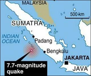
The 7.7-magnitude earthquake, which struck in the Mentawai Islands area west of Sumatra late Monday, caused waves as high as three metres (10 feet) that damaged residential areas in several islands.
A tsunami warning was issued after the quake and a group of Australian visitors reported that their boat was destroyed by a "wall of white water" crashing into a bay.
Rick Hallet, an Australian who operates a boat-chartering business in Sumatra, said he had 15 people on board his vessel in a bay off the islands when the quake struck.
"We felt a bit of a shake underneath the boat... then within several minutes we heard an almighty roar... I immediately thought of a tsunami and looked out to sea and that's when we saw the wall of white water coming at us," he said.
Arlyno, an official from the Disaster Management Agency, told AFP that 23 people were killed in the Mentawai islands and that 167 people had gone missing.
While remote, the Mentawai Islands are popular with tourists, especially surfers.
Health Ministry Crisis Centre head Mudjiharto, who goes by one name, said the waves reached three metres high and waters swept as far as 600 metres inland on South Pagai island, one of the Mentawai chain.
"Eighty percent of buildings in Muntei village have been damaged by the waves and many people are missing there," Mudjiharto said.
He said medical personnel were on their way to the hardest-hit areas.
Rescuers launched a hunt for a boat believed to be carrying a group of nine Australians which has been missing since the quake.
"We are sending a boat and a chartered plane to search for the boat," said Andrew Judge of SurfAid International.
It was reportedly not equipped with a satellite telephone but SurfAid's Dave Jenkins said its Australian captain Chris Scurrah had "been around here for a long time. He knew to contact in if he could. So that's why we're extra concerned."
The undersea quake hit at 9:42pm (1442 GMT) at a depth of 20.6 kilometres (12.8 miles), 240 kilometres west of Bengkulu on Sumatra island and 280 kilometres south of Padang, the US Geological Survey said.
"A significant tsunami was generated by this earthquake," said the Pacific Tsunami Warning Center. The warning was later withdrawn after the danger of further waves had passed.
The first tremor was followed by strong magnitude 6.1 and 6.2 aftershocks several hours later.
Hallet recounted his group's ordeal when the quake struck, with some climbing trees to survive.
"The bay we were in was several hundred metres across and the wall of white water was from one side to the other, it was quite scary," he told Fairfax Radio Network.
Another boat was anchored next to them, he said.
"The wave picked that boat up and brought it towards us and ran straight into us and our boat exploded, caught on fire, we had a fireball on the back deck and right through the saloon within seconds.
"I ordered everyone up to the top deck to get as high as possible, then the boat exploded and we had to abandon ship," he told Australia's Nine Network.
The group jumped into the water, some of them being swept 200 metres inland, and took shelter by climbing trees, waiting for 20 minutes to half an hour until the surges passed.
Eventually all the group, nine of whom were Australian, were accounted for, he said.
Residents reported shaking as far away as the West Sumatran provincial capital of Padang when the main quake struck.
Indonesia sits on the Pacific "Ring of Fire," where the meeting of continental plates causes high volcanic and seismic activity, and the archipelago is frequently struck by powerful earthquakes.
A 7.1-magnitude quake off the north coast of Papua in June killed 17 people and left thousands homeless.
The 2004 Asian tsunami -- triggered by a 9.3-magnitude quake off Sumatra --
killed at least 168,000 people in Indonesia alone.
A 7.6-magnitude quake killed about 1,000 people in the port of Padang on September 30 last year.
- AFP/ir

JAKARTA - At least 23 people are dead and scores missing, including nine Australians, after a powerful earthquake hit Indonesia's west coast and triggered a tsunami, officials said Tuesday.
The 7.7-magnitude earthquake, which struck in the Mentawai Islands area west of Sumatra late Monday, caused waves as high as three metres (10 feet) that damaged residential areas in several islands.
A tsunami warning was issued after the quake and a group of Australian visitors reported that their boat was destroyed by a "wall of white water" crashing into a bay.
Rick Hallet, an Australian who operates a boat-chartering business in Sumatra, said he had 15 people on board his vessel in a bay off the islands when the quake struck.
"We felt a bit of a shake underneath the boat... then within several minutes we heard an almighty roar... I immediately thought of a tsunami and looked out to sea and that's when we saw the wall of white water coming at us," he said.
Arlyno, an official from the Disaster Management Agency, told AFP that 23 people were killed in the Mentawai islands and that 167 people had gone missing.
While remote, the Mentawai Islands are popular with tourists, especially surfers.
Health Ministry Crisis Centre head Mudjiharto, who goes by one name, said the waves reached three metres high and waters swept as far as 600 metres inland on South Pagai island, one of the Mentawai chain.
"Eighty percent of buildings in Muntei village have been damaged by the waves and many people are missing there," Mudjiharto said.
He said medical personnel were on their way to the hardest-hit areas.
Rescuers launched a hunt for a boat believed to be carrying a group of nine Australians which has been missing since the quake.
"We are sending a boat and a chartered plane to search for the boat," said Andrew Judge of SurfAid International.
It was reportedly not equipped with a satellite telephone but SurfAid's Dave Jenkins said its Australian captain Chris Scurrah had "been around here for a long time. He knew to contact in if he could. So that's why we're extra concerned."
The undersea quake hit at 9:42pm (1442 GMT) at a depth of 20.6 kilometres (12.8 miles), 240 kilometres west of Bengkulu on Sumatra island and 280 kilometres south of Padang, the US Geological Survey said.
"A significant tsunami was generated by this earthquake," said the Pacific Tsunami Warning Center. The warning was later withdrawn after the danger of further waves had passed.
The first tremor was followed by strong magnitude 6.1 and 6.2 aftershocks several hours later.
Hallet recounted his group's ordeal when the quake struck, with some climbing trees to survive.
"The bay we were in was several hundred metres across and the wall of white water was from one side to the other, it was quite scary," he told Fairfax Radio Network.
Another boat was anchored next to them, he said.
"The wave picked that boat up and brought it towards us and ran straight into us and our boat exploded, caught on fire, we had a fireball on the back deck and right through the saloon within seconds.
"I ordered everyone up to the top deck to get as high as possible, then the boat exploded and we had to abandon ship," he told Australia's Nine Network.
The group jumped into the water, some of them being swept 200 metres inland, and took shelter by climbing trees, waiting for 20 minutes to half an hour until the surges passed.
Eventually all the group, nine of whom were Australian, were accounted for, he said.
Residents reported shaking as far away as the West Sumatran provincial capital of Padang when the main quake struck.
Indonesia sits on the Pacific "Ring of Fire," where the meeting of continental plates causes high volcanic and seismic activity, and the archipelago is frequently struck by powerful earthquakes.
A 7.1-magnitude quake off the north coast of Papua in June killed 17 people and left thousands homeless.
The 2004 Asian tsunami -- triggered by a 9.3-magnitude quake off Sumatra --
killed at least 168,000 people in Indonesia alone.
A 7.6-magnitude quake killed about 1,000 people in the port of Padang on September 30 last year.
- AFP/ir
Major 7.7 quake strikes Indonesia
Posted: 26 October 2010 1341 hrs
JAKARTA: A major 7.7-magnitude earthquake struck off the west coast of Indonesia on Monday, seismologists said, causing localised waves in the remote area.
A tsunami warning was issued, and while it was later withdrawn and no casualties were confirmed, a group of Australian visitors reported that their boat was destroyed by a "wall of white water" crashing into a bay.
The undersea quake hit Indonesia's Kepulauan Mentawai region at 9:42 pm (1442 GMT) at a shallow depth of 20.6 kilometres (12.8 miles), the US Geological Survey said.
The Mentawai Islands, 240 kilometres west of Bengkulu on Sumatra island and 280 kilometres south of Padang, are popular with tourists.
Rick Hallet, an Australian who operates a boat-chartering business in Sumatra, had 15 people on board his vessel in a bay off the islands when the quake struck.
"We felt a bit of a shake underneath the boat... then within several minutes we heard an almighty roar... I immediately thought of a tsunami and looked out to sea and that's when we saw the wall of white water coming at us," he said.
"The bay we were in was several hundred metres across and the wall of white water was from one side to the other, it was quite scary," he told Fairfax Radio Network.
Another boat was anchored next to them, he said. "The wave picked that boat up and brought it towards us and ran straight into us and our boat exploded, caught on fire, we had a fireball on the back deck and right through the saloon within seconds.
"I ordered everyone up to the top deck to get as high as possible, then the boat exploded and we had to abandon ship," he told Australia's Nine Network.
The group jumped into the water, some of them being swept 200 metres inland, and took shelter by climbing trees, waiting for 20 minutes to half an hour until the surges passed.
Eventually the group, nine of whom were Australian, was accounted for, he said.
The 7.7 earthquake was followed by powerful magnitude 6.1 and 6.2 aftershocks about five and eight hours later in the same area.
Residents reported shaking as far away as the West Sumatran provincial capital of Padang relating to the earlier quake, but fears of widespread damage eased a few hours later.
"There was shaking that went on for about three seconds or so. Residents panicked and ran to the hills but now they are starting to come down. There's no report of casualties or damage," Disaster Management Agency spokesman Priyadi Kardono told AFP.
The Indonesian Geophysics and Meteorology agency lifted an earlier tsunami warning.
The power and shallow depth of the earthquake prompted the US-based Pacific Tsunami Warning Center to issue a "tsunami watch" bulletin to guide local authorities on how to respond but that was later cancelled.
Indonesia sits on the Pacific "Ring of Fire," where the meeting of continental plates causes high volcanic and seismic activity, and the archipelago is frequently struck by powerful earthquakes.
A 7.1-magnitude quake off the north coast of Papua in June killed 17 people and left thousands homeless.
The 2004 Asian tsunami -- triggered by a 9.3-magnitude quake off Sumatra -- killed at least 168,000 people in Indonesia alone.
A 7.6-magnitude quake killed about 1,000 people in the port of Padang on September 30 last year.
-AFP/wk
Sunday, October 3, 2010
Earthquake hits central Japan
Posted: 03 October 2010 0851 hrs
TOKYO: A 4.7-magnitude quake hit areas some 200 kilometres (125 miles) north of Tokyo Sunday, but no tsunami warning was issued, Japan's meteorological agency said.
The quake hit Jetsu City and surrounding areas at 9:26am (0026 GMT) at a depth of 20 kilometres, the agency said.
Around 20 per cent of the world's most powerful earthquakes strike Japan, which has developed one of the most sophisticated tsunami warning systems.
Just a moment before the quake struck, warnings for a strong tremor were flashed across television screens.
There were no immediate reports of damage.
-AFP/wk
Friday, October 1, 2010
Moderate quake jolts Taiwan
Posted: 01 October 2010 0939 hrs
TAIPEI: A 5.1-magnitude earthquake struck off northern Taiwan Friday, the island's Seismology Centre said, but there were no immediate reports of damage and no tsunami warning was issued.
The quake hit at 3:56 am (2156 GMT Thursday) 11 kilometres (seven miles) north of the city of Ilan at a depth of 102 kilometres.
Taiwan lies near the junction of two tectonic plates and is regularly hit by earthquakes.
In September 1999, a 7.6-magnitude quake killed around 2,400 people in the deadliest natural disaster in the island's history.
-AFP/wk
Thursday, September 9, 2010
6.1-magnitude quake strikes near Chile coast
Posted: 09 September 2010 1637 hrs
WASHINGTON : A strong 6.1-magnitude earthquake struck just off the coast of central Chile early Thursday, the US Geological Survey reported.
The Pacific Tsunami Warning Center has not issued an advisory on the quake, which hit at 3:28 am (0728 GMT) about 35 kilometres (20 miles) southwest of the coastal city of Concepcion, at a depth of 17 kilometres (10 miles).
The quake struck close to the epicentre of a massive 8.8-magnitude earthquake that rocked Chile on February 27, sparking a huge tsunami that killed 521 people and swept away entire villages. - AFP/ms
Saturday, September 4, 2010
Widespread devastation after 7.0 quake
AFP - 1 hour 55 minutes ago
CHRISTCHURCH (AFP) - – A powerful 7.0 magnitude earthquake caused widespread devastation in New Zealand's second largest city of Christchurch Saturday, with officials saying it was "extremely lucky" no one was killed.
Initial estimates put the damage at up to two billion dollars (1.44 billion US) as buildings collapsed, gas, water and sewage lines were ruptured, some bridges became impassable and electricity supplies were cut.
Frightened residents fled from their homes to find streets covered in rubble and glass, but despite the extent of the damage only two people were seriously injured in the city of 340,000 people.
The quake struck just before dawn when few people were on the streets as building facades crashed to the ground, crushing parked cars and showering the roads with shattered glass.
A state of emergency was declared in Christchurch and a 7:00 pm to 7:00 am curfew imposed in the city centre as residents were warned to stay away from damaged buildings for fear of further collapses as severe aftershocks continued to rock the city.
"I think we've been extremely lucky as a nation that there's been no fatalities... we're blessed actually," Civil Defence Minister John Carter said after being briefed on the impact of the quake.
He described it as a "significant disaster" and urged people "don't panic" as strong aftershocks continued throughout the day. Facts:Quake among New Zealand's worst
Christchurch mayor Bob Parker said he was "horrified by the amount of damage" which daylight showed was considerably worse than first thought.
"We've decided to declare the state of emergency in the city. It just makes it a bit easier for us now to move people out of buildings if necessary, close streets down," Parker announced on national radio.
"There would not be a house, there would not be a family in our city that has not in some way have damage done to their person, to their property.
"I think it's like an iceberg; there is ... below the visible line, significant structural damage."
The quake, initially recorded at a magnitude of 7.4, struck at 4:35 am (1635 GMT Friday) at a depth of five kilometres (three miles) some 45 kilometres west of Christchurch, the US Geological Survey said.
"Oh my God. There is a row of shops completely demolished right in front of me," resident Colleen Simpson told the Stuff website, adding that many people had run out onto the streets in fear.
Christchurch Hospital spokeswoman Michele Hider said two men in their 50s were seriously injured -- one was hit by a falling chimney and the other was cut by falling glass.
Police closed the centre of the city as looters targeted damaged shops, police Inspector Mike Coleman said.
"There's considerable damage there, and we've already had reports of looting. Shop windows are broken and obviously it's easy pickings for displays and things."
In the hours immediately after the quake, roads in the seaside suburbs were packed with cars as residents moved inland, but there was no tsunami.
Kevin O'Hanlon, from the Mairehau area of Christchurch, said: "Just unbelievable. I was awake to go to work and then just heard this massive noise and, boom, it was like the house got hit. It just started shaking. I've never felt anything like it."
Mayor Parker said he was in bed when the quake struck and he was "absolutely scared. I've never felt anything like it and I've experienced, like most Kiwis, a number of good shakes." Related article:City 'wobbles like jelly' in powerful quake
The quake, felt throughout the South Island and the lower North Island, was the most destructive in New Zealand since the 1931 tremor in Hawke's Bay that killed 256 people.
It caused the temporary shutdown of Christchurch International Airport, forcing the diversion of inbound international flights to Auckland and Wellington until it reopened Saturday afternoon after being assessed for damage.
New Zealand sits on the so-called "Ring of Fire", the boundary of the Australian and Pacific tectonic plates, and experiences up to 15,000 tremors a year. It averages at least one a day that is magnitude 4.0 or stronger.
Saturday, August 28, 2010
Three killed, 40 injured in Iran quake
Posted: 28 August 2010 1250 hrs
TEHRAN - Three people, including two children, have been killed and 40 others injured in an earthquake which struck Iran's biggest desert, Dasht-e Kavir, state television reported on Saturday.
The 5.9 magnitude quake struck on Friday south of the northern city of Damghan.
In a separate report, the state television website quoted secretary general of Iran Red Crescent, Zaher Rostani, as saying that an elderly woman was also among those killed in the quake.
The website said six villages near Damghan were damaged in the quake which was about 278 kilometres (167 miles) east of Tehran.
The tremor, which struck at 11:53 pm (1923 GMT) Friday, was also felt in the capital Tehran.
Iran sits astride several major fault lines in the Earth's crust, and is prone to frequent earthquakes, many of which have been devastating.
The worst in recent times was a 6.3 magnitude quake which hit the southern city of Bam in December 2003, killing 31,000 people, about a quarter of its population, and destroying the city's ancient mud-built citadel.
- AFP /ls
Sunday, August 22, 2010
Moderate earthquake in sea off Greece
Posted: 22 August 2010 2157 hrs
ATHENS : A moderate earthquake of 5.4 magnitude hit an area in the Ionian Sea off the coast of Greece on Sunday without causing casualties or major damage, Greek and US authorities reported.
The epicentre of the tremor, which occurred at 1023 GMT, was located near the island of Zante, 329 kilometres (203 miles) west of Athens, seismologists at the Athens observatory said.
The quake was felt most strongly on Zante, local police said.
The US Geological Survey rated the magnitude as 5.6.
Greece is the European nation most exposed to earthquakes, experiencing about half of all those recorded on the continent. - AFP/ms
5.6-magnitude quake strikes off Mariana Islands
Posted: 22 August 2010 1847 hrs
SAIPAN, Northern Mariana Islands : An earthquake with a magnitude of 5.6 hit the Mariana Islands region on Sunday, a week after a 7.2 tremor and a series of strong aftershocks, US geologists said.
The latest quake struck at 7:33pm (0933 GMT) at a depth of 49 kilometres (30 miles) and was centred 505 kilometres from the Northern Marianas capital Saipan, the US Geological Survey said.
There have been more than 10 quakes of magnitude 5.0 or stronger since the powerful quake on August 14, but all were in a remote area of the Pacific Ocean and well away from populated areas.
The Hawaii-based Pacific Tsunami Warning Center said there was no indication of any widespread tsunami threat. - AFP/ms
Thursday, August 19, 2010
Rare double quake blamed for South Pacific tsunami
By ALICIA CHANG, AP Science Writer– Wed Aug 18, 11:05 am ET
LOS ANGELES – The deadly tsunami that pounded several South Pacific islands last year was spawned by not one but two monstrous earthquakes, surprising new research reveals.
Initially, it was thought that a single powerful magnitude-8.1 jolt triggered the tsunami last September 29 that killed nearly 200 people in Samoa, American Samoa and Tonga.
Two teams using different research techniques have now separately concluded that the disaster was the result of a rare double whammy — two so-called great earthquakes with magnitudes greater than 8 — that hit within minutes of each other.
What's notable, they say, was that the quakes occurred along separate fault lines and ruptured differently.
Although the researchers differed on which struck first, their discovery of a one-two seismic punch solves a mystery that has baffled scientists since the disaster.
The findings are published in Thursday's issue of the journal Nature.
When the South Pacific sea floor rumbled last year, scientists initially blamed it on a "outer rise" earthquake of magnitude-8.1 caused by the flexing and bending of the Pacific tectonic plate. But tsunami waves did not arrive at the predicted times and the aftershocks did not cluster around the main quake — as they normally would — suggesting that something more complicated was at play.
Using GPS data and deep-ocean tsunami wave observations, a group led by geophysicist John Beavan of the New Zealand geological agency GNS Science determined that the tsunami was actually generated by two powerful quakes — the magnitude-8.1 "outer rise" quake and a magnitude-8 "megathrust" jolt caused by the diving of one plate under another.
While Beavan's group is not sure which hit first, a separate team led by Thorne Lay of the University of California, Santa Cruz, concluded the magnitude-8.1 quake unleashed the megathrust jolt. Normally, megathrust quakes trigger other jolts. Ground vibrations from the first were so strong that they masked the energy released by the second quake.
The second tremor "does show up clearly on seismic records, but only once you look very hard," Lay said.
Scientists not involved in the latest research said the findings shed light on what happened in the South Pacific, but more work is needed.
"It is difficult to say how typical this behavior is in the region," said U.S. Geological Survey geophysicist Paul Earle. That's because there's a long time between earthquakes and modern instruments weren't available for previous massive earthquakes, he said.
___
Thursday, August 12, 2010
Strong earthquake rattles Ecuador and Peru
Posted: 12 August 2010 2236 hrs
WASHINGTON: A strong 7.1-magnitude earthquake rocked Ecuador and parts of Peru on Thursday, but its epicentre was deep underground in a remote Amazonian region and only one injury and light damage was reported.
The quake, which experts from the US Geological Survey said hit at 6:54 am (1154 GMT), 175 kilometres southeast of Quito, lasted for about 40 seconds and was felt around the country and in neighbouring Peru.
One person in a southwestern fishing port was injured by a crumbling wall, Ecuador Red Cross spokesman Jorge Arteaga told AFP.
"So far that is the only victim," he said, adding that a handful of buildings including a firehouse had their walls crumble as a result of the quake.
The epicenter of the quake was deep, some 210 kilometres under the Amazonian jungle, which Ecuadoran officials said was the reason for the lack of damage above ground. No tsunami was generated.
The USGS said the nearest urban centre was some 145 kilometres to the west - Ambato - an Ecuadoran city high in the Andes mountains which is home to a volcano of the same name and suffered a devastating quake back in 1949.
The Geophysical Institute of Peru said Thursday's quake was also felt by Peruvians along the border in the Amazonian jungle regions.
Sandro Vaca, an expert from the Geophysical Institute of Ecuador, said no aftershocks had been detected during the morning.
The USGS revised its estimate of the quake's magnitude several times, from 6.9 to 7.2 and then back to a 6.9 before finally settling on 7.1.
Ecuadoran experts first put the quake at 6.9 on the Richter scale before revising the magnitude upwards to 7.2.
The USGS uses the moment magnitude scale, which measures the amount of movement on the underground fault and the area of the fault that ruptured.
Many seismologists now use that system rather than the Richter scale, which measures the size based upon the amount of ground shaking.
According to the USGS, the quake was the largest involving Ecuador since a 7.2-magnitude temblor off the coast in 1998. Ecuador's deadliest was the 6.8-magnitude quake in 1949 in Ambato which killed more than 5,000 people.
The Ecuadoran Andes are part of the Pacific Ring of fire, where most of history's deadliest quakes, tremors and volcanic explosions have occurred.
The weak line in the Earth's crust stretches along the western coast of the Americas and through the island nations of the South Pacific and on through Southeast Asia.
- AFP/ls/de
Tuesday, August 10, 2010
Moderate quake hits northern Japan
Posted: 10 August 2010 1516 hrs
TOKYO: A 5.8-magnitude earthquake hit northern Japan Tuesday, but there was no tsunami warning and no immediate reports of damage, US and Japanese seismologists said.
The underwater quake occurred at 2:50 pm (0550 GMT) off Iwate prefecture in the Pacific, 515km (320 miles) north of Tokyo, according to the US Geological Survey.
Its depth was estimated at 21km, the USGS said.
No tsunami warning was issued by the Japan Meteorological Agency.
Around 20 per cent of the world's most powerful earthquakes strike Japan, which has developed one of the most sophisticated tsunami warning systems.
-AFP/wk
Major 7.5 earthquake, tsunami hit Pacific's Vanuatu
Posted: 10 August 2010 1505 hrs
SYDNEY: A major 7.5-magnitude earthquake hit the Pacific island nation of Vanuatu on Tuesday, generating a small tsunami and sending thousands of frightened people running for the hills.
The undersea quake, 35km deep and just 40km from the capital Port Vila, shook buildings in the city for about 15 seconds, but did not appear to have caused significant damage.
Foreign hotel guests and some residents raced to higher ground in case of a possible tsunami, locals said, while police sounded sirens to warn people to evacuate.
"We don't have any damage. But we have evacuated our guests to the top of the hill just to be safe, although we have not received any tsunami warning yet," hotel employee Rowan Lulu told AFP.
"A lot of people are evacuating to higher ground in the city as a precaution but as far as I know there is no major damage in Vila, just things falling off shelves," he said.
"We felt it very strongly," another hotel employee said.
Witnesses said people working in the capital's tallest buildings were also evacuated, while the powerful quake was felt in the archipelago's other islands further north.
"People were moving to higher ground," resident Steve Ayong-Nirua told AFP.
"There was a call on the radio calling on drivers to drive slowly in case of aftershocks," he added.
The Pacific Tsunami Warning Centre said a 23cm (9.2 inch) tsunami hit Port Vila, but warned bigger waves may be seen in other areas.
"Higher wave amplitudes may yet be observed along coasts near the earthquake epicentre," the Centre said.
Vanuatu, which lies between Fiji and Australia and north of New Zealand, is in the "Pacific Ring of Fire" known for its high seismic and volcanic activity caused by friction between moving plates in the Earth's crust.
In May, a 7.2 earthquake prompted a brief tsunami alert, and at least three earthquakes measuring 6.0 or stronger have hit the archipelago since the start of July.
The country was hit by three major quakes last October, while a giant plume of volcanic ash disrupted domestic flights in neighbouring New Caledonia in recent months.
The US Geological Survey measured the latest earthquake at 7.5 while Geoscience Australia said it was 7.6 and at a depth of 60km.
The Pacific centre said it did not cause a widespread tsunami, while scientists in New Zealand believed the country was not under threat from any destructive waves.
-AFP/wk
Friday, August 6, 2010
5.6-magnitude quake strikes Indonesia
Posted: 06 August 2010 1734hrs
JAKARTA : A moderate 5.6-magnitude earthquake struck the Indonesian province of Maluku on Friday, the local Meteorological and Geophysics agency said, but no tsunami warning was issued.
The quake struck at 3:58 pm (0858 GMT), 317 kilometres (196 miles) northwest of Saumlaki at a depth of 10 kilometres, according to the agency.
Indonesia sits on the Pacific "ring of fire", where the meeting of continental plates causes high volcanic and seismic activity. - AFP/ms
Monday, July 26, 2010
5.6-magnitude quake hits Taiwan
Posted: 25 July 2010 1222 hrs
TAIPEI - A 5.6-magnitude earthquake rocked Taiwan Sunday, swaying buildings in the capital Taipei, the island's Seismology Centre said, but there were no immediate reports of damage or casualties.
The quake hit at 0352 GMT about 31 kilometres northeast of Pingtung county at a depth of 20 kilometres.
Taiwan is regularly hit by earthquakes as the island lies near the junction of two tectonic plates.
In September 1999, a 7.6-magnitude quake killed around 2,400 people in the deadliest natural disaster in the island's history.
- AFP/ir
Saturday, July 24, 2010
Tremors felt in Singapore from earthquake in North Sumatra
By Joanne Chan | Posted: 24 July 2010 1146 2010 1146 hrs
SINGAPORE: Tremors were felt in parts of Singapore Saturday morning.
Callers to the MediaCorp Hotline said the tremors, which lasted about a minute, were felt in places such as Farrer Road, Cecil Street and North Bridge Road.
Lynn Jamaludin was in her office, located on the 24th floor of Tong Eng Building on Cecil Street, when the tremors hit at around 10am.
She said: "We actually felt the desk shaking slightly, and then we felt the building was moving a bit. But it stopped after about 50 seconds. We waited for the second tremor but it didn't come so we decided to stay in the office."
The National Environment Agency's Meteorological Services Division said an earthquake of magnitude 6.25 hit northern Sumatra at 10.11am Singapore time.
The quake epicentre was some 450 kilometres from Singapore.
NEA says there is no tsunami threat to Singapore.
- CNA/jm
Three major quakes rattle Philippines
Posted: 24 July 2010 0659 hrs
MANILA: Three major quakes measuring between magnitude 7.3 and 7.6 hit the southern Philippines early Saturday, seismologists said, but there were no reports of damage and no tsunami warning was issued.
The underwater quakes struck at a depth of between 575 and 605 kilometres (350 and 375 miles), just over 100 kilometres southwest of Cotabato, on the island of Mindanao, said the US Geological Survey.
The Hawaii-based Pacific Tsunami Warning Center said no destructive tsunami was generated by the 7.3-, 7.6- and 7.4-magnitude quakes, the first of which hit at 6:08 am (2208 GMT Friday).
"It was kind of mild," said Monisa Tulawie, a staff member at the Cotabato city mayor's office, who told AFP she felt one of the quakes.
Other residents contacted by phone were unaware of what had happened, saying they had not been woken by the tremors.
"We have received no reports of damage or casualties," said local fire official Marlon Macapili of the Autonomous Region in Muslim Mindanao, a self-ruled area that includes four provinces around Cotabato.
Renato Solidum, chief of the Philippine Institute of Volcanology and Seismology, said the strong quakes struck over a 67-minute period at sunrise, with several moderate aftershocks.
Mild tremors were felt as far north as Manila, more than 800 kilometres away, he added.
"We don't expect any," Solidum told AFP when asked about damage or casualties. "Because of their depth they will not be able to depress the ocean floor," Solidum added.
The institute said quakes with a magnitude of 7.0 or above can cause considerable damage near their epicentre, while shallow-seated ones occurring under the sea may generate huge waves.
The Philippines is an archipelago of more than 7,000 islands with many people living in communities close to the sea.
The country sits on the Pacific Ring of Fire, where continental plates meet, causing frequent seismic and volcanic activity.
Solidum said a movement of the Molucca Sea Plate had caused Saturday's quakes. The plate is pushing underneath the Indonesian archipelago.
- AFP/fa/jm
Wednesday, July 14, 2010
New quake hits Chile's central coast
Posted: 14 July 2010 1758 hrs
WASHINGTON : A 6.5-magnitude earthquake rocked Chile's central coast on Wednesday, the US Geological Service reported.
The temblor hit at 0832 GMT about 99 kilometres (61 miles) northwest of Temuco, Chile, at a depth of 28 kilometres, the USGS added.
A massive 8.8-magnitude earthquake struck Chile on February 27, sparking a huge tsunami that killed 521 people and swept away entire villages. The disaster caused an estimated 30 billion dollars in damage. - AFP/ms
Wednesday, July 7, 2010
No damage reported after quake hits southern California
July 8, 2010 -- Updated 0056 GMT (0856 HKT)
(CNN) -- A 5.4-magnitude earthquake rattled southern California Wednesday, the U.S. Geological Survey said. The temblor, centered about 60 miles northeast of San Diego, was first reported by USGS to be at 5.7 magnitude but the agency later downgraded it to 5.4.
There were no immediate reports of damages or injuries.
The city closest to the quake was Borrego Springs, located in San Diego County.
"(There was) no damage no injures whatsoever," San Diego County Fire Department spokesman Maurice Luque told CNN. "Not even a spike in call volume at our 911 center which normally happens when we have a quake of this magnitude."
Neighboring Riverside County also reported no major incidents as a result of the quake.
"So far in Riverside County we have had no significant damage reports either from our fire stations of from the citizens in the county," Riverside Fire Capt. Jeremy Snyder told CNN.
In Palm Springs, businesses reported feeling the quake, but suffered no damage. Palm Springs was about 28 miles from the epicenter of the quake.
An employee at Le Parker Meridian Hotel in Palm Springs described the quake as a "pretty big jolt."
At Jensen's Finest Food in Palm Springs, manager Tom Hodges said he had maybe 20 items fall off the shelves, but not a single broken glass.
Saturday, June 26, 2010
Strong 6.3 quake hits Indonesia's Java
Strong 6.3 quake hits Indonesia's Java
Posted: 26 June 2010 1843 hrs
JAKARTA - A strong earthquake struck off Indonesia's Java island Saturday but there were no immediate reports of damage and no tsunami warning was issued, seismologists said.
The quake struck at 4:50 pm (0950 GMT), 118 kilometres (73 miles) south west of Tasikmalaya, West Java, at a depth of 34 kilometres, Indonesia's geophysics and meteorological agency said.
The Indonesian agency measured the quake as magnitude 6.3, but the US Geological Survey (USGS) measured it at 5.8.
Indonesia sits on the Pacific "Ring of Fire," where the meeting of continental plates causes high volcanic and seismic activity. - AFP/vm
Wednesday, June 16, 2010
Quakes kill three in Indonesia
Posted: 16 June 2010 1156 2010 1156 hrs
MANOKWARI, Indonesia : A powerful 7.1-magnitude earthquake killed at least two people and damaged hundreds of homes in eastern Indonesia on Wednesday, triggering a tsunami warning and widespread panic.
The victims were crushed when their homes collapsed on Yapen island, close to the epicentre off the northern coast of Papua province, police said.
"Two people, a child and an adult woman, were killed by falling debris of houses," Yapen Island police chief Deny Siregar said.
The quake struck off the southeast coast of Yapen at 12:16 pm (0316 GMT), officials said. It was the second of a series of strong quakes felt across a vast but sparsely populated area including Biak island.
Another person was killed when a 5.3-magnitude quake rattled West Sulawesi province, the Antara news agency reported.
Indonesia's Geophysics and Meteorological Agency issued a tsunami warning for waters off northern Papua but it was lifted an hour later.
"I was driving my car to the office... I felt a huge tremor for about one or two minutes. The car was being flung around," Biak resident Osibyo Wakum said.
He said people rushed out of homes and buildings as the quake rocked the reef-fringed tropical island around lunchtime.
About 500 homes, a church, a power station and government buildings were destroyed or damaged on Yapen, which has a population of about 70,000, police and officials said.
Officials said people were evacuated to higher ground due to fears of a tsunami, but by mid-afternoon they had returned and the situation was normal.
"Residents have returned to their homes and gone back to doing their normal activities," Disaster Management Agency official Slamet Sugiyono said, adding that helicopters and speed boats were being used to survey the damage.
Thousands of people also fled their homes and workplaces in the West Papua provincial capital of Manokwari about 300 kilometres (180 miles) to the northwest of the epicentre.
"There was a swaying movement for about 40 seconds. People ran out of their homes, shouting 'get out, get out, the earth is shaking'," said an AFP correspondent in Manokwari.
Many people remained outside as a series of powerful aftershocks, the strongest with a magnitude of 6.6, shook the region.
Antara reported that the man killed on Sulawesi island was working in a sand mine when the earlier quake struck. About 50 houses were destroyed and a landslide injured several people, local officials said.
The vast Indonesian archipelago stretches from the Pacific to the Indian oceans and straddles major seismic faultlines that trigger thousands of quakes a year.
The 2004 Asian tsunami killed at least 168,000 people in Indonesia alone when the sea surged over the northern tip of Sumatra island after a 9.3-magnitude quake split the seabed to the west.
A 7.6-magnitude quake killed about 1,000 people in the port of Padang, western Sumatra, in September last year.
A 7.8-magnitude earthquake hit northern Sumatra in April but caused no significant damage.
Scientists cannot predict when the next major earthquake will hit Indonesia but they say it is only a matter of time before another catastrophe on the same or even greater scale as 2004 strikes the archipelago again.
- AFP/ir
Sunday, June 13, 2010
Strong 6.1-magnitude quake off Japan, no tsunami warning
Posted: 13 June 2010 1202 hrs
TOKYO - A strong quake with a magnitude of 6.1 hit off Japan's Honshu island Sunday, but no tsunami warning was immediately issued, seismologists said.
The quake struck at 12:33 pm (0333 GMT) at a depth of 40 kilometres (25 miles), some 100 kilometres from Fukushima prefecture north of Tokyo, Japan's Meteorological Agency said.
There was no likelihood of a tsunami, the agency said.
There was no immediate report of damage or injuries, an official in Fukushima prefecture said.
The US Geological survey said the quake had a magnitude of 6.1, while the Japanese agency said it measured 6.2.
The USGS had originally recorded the quake at 6.4.
- AFP /ls
Major 7.5-magnitude quake strikes off India's Nicobar Islands
Posted: 13 June 2010 0403 hrs
NEW DELHI: A 7.5-magnitude earthquake struck under the Indian Ocean on Sunday, triggering a tsunami watch for nearby islands and causing tremors reportedly felt along India's eastern seaboard.
The quake hit at 1:26 am local time (1926 GMT) at a depth of 35 kilometres with the epicentre around 160 kilometres west of India's Nicobar Islands.
The Pacific Tsunami Warning Centre, based in Hawaii, initially issued a warning for the entire Indian Ocean region. This was downgraded to a warning for India only, when the magnitude of the quake was revised to 7.5 from 7.7, and later the centre cancelled the alert altogether.
India's ocean information centre issued a "tsunami watch" for 10-15 islands, but said it was expecting only a mild surge in sea levels of about 50 centimetres.
"This is nothing alarming, but just a watch," Sriniwas Kumar, a spokesman from the state-run Indian National Centre for Ocean Information Services told AFP by telephone from the agency's headquarters in Hyderabad.
The tremors were felt more than 1,000 kilometres from the epicentre on mainland India, where many were shaken awake in the dead of night, causing some to flee their homes in panic, the Press Trust of India reported.
Moderate tremors were felt in the southeastern coastal city of Chennai, but there were no reports of casualties or damage to property, according to police.
The US Geological Survey initially gave the magnitude of the quake as 7.7 before revising it down to 7.5.
Indian Ocean islands were badly hit by the 2004 Asian tsunami which was triggered by an earthquake off the Indonesian island of Sumatra and sent giant waves crashing across the region.
The 2004 tsunami killed more than 220,000 people, most of them in the northern Indonesian province of Aceh. Thousands of people were also killed in Sri Lanka, Myanmar, Thailand and India.
The Andaman and Nicobar Islands are some of India's most easterly territories and more than 350,000 people live on the 572 islands flanked by the Andaman Sea and the Bay of Bengal.
The Andaman Sea area witnesses frequent earthquakes caused by the meeting of the Indian tectonic plate with the Burmese microplate along an area known as the Andaman trench.
- AFP/de
Wednesday, June 2, 2010
Moderate quake hits Papua New Guinea: US seismologists
PORT MORESBY (AFP) - – A moderate, 5.8-magnitude quake struck Papua New Guinea Wednesday, US seismologists said, lowering previous estimates.
The quake struck at 0928 GMT with its epicentre 25 kilometres (15 miles) west of the town of Kandrian on New Britain island at a depth of about 52 kilometres, the United States Geological Survey said.
An initial report by the USGS estimated the quake at 6.2 magnitude at a depth of 40 kilometres.
There was no alert from the Pacific Tsunami Warning Centre in Hawaii.
Geoscience Australia, which also put the quake's epicentre at a depth of 52 kilometres, did not change its estimate of a strong, 6.2 magnitude earthquake.
"People close to it would have felt it quite strongly," Geoscience Australia seismologist David Jepsen told AFP. "There's possibly some local damage.
"With other events of that sort of magnitude and in that area, typically you don't hear of much damage...."
Papua New Guinea, which is mired in poverty despite rich mineral deposits, sits on the so-called "Pacific Ring of Fire", a hotspot for seismic activity due to friction between tectonic plates.
Saturday, May 29, 2010
5.4 quake hits northwest China
BEIJING : A 5.4-magnitude earthquake hit China's remote northwestern Qinghai province Saturday, the US Geological Survey said, in the same region where a strong quake killed more than 2,000 people last month.
The quake, which struck at 10:29 am (0229 GMT), was centred in Yushu prefecture, 376 kilometres (234 miles) south-southeast of Golmud at a depth of 50 kilometres.
The remote, high-altitude region, which borders northern Tibet, is sparsely populated.
China's seismological bureau said the quake had a magnitude of 5.7.
In April, a powerful, 6.9-magnitude quake struck the same region, killing more than 2,000 peopleand flattening thousands of homes in Yushu, an ethnically Tibetan region.
There were no immediate reports of any injuries or damage caused by the latest quake.
An official at the Yushu prefecture civil affairs bureau told AFP: "Yes, we felt the quake here. We are now trying to find the epicentre and whether it has caused any damage." - AFP/jy
Sunday, May 9, 2010
Powerful quake hits Indonesia's Aceh
AFP - 39 minutes ago
BANDA ACEH, Indonesia (AFP) - – A powerful quake with a magnitude of at least 7.2 hit the Indonesian province of Aceh on Sunday, causing panic in an area that was devastated by the killer waves of the 2004 tsunami.
Coastal residents fled from their homes and headed inland fearing a destructive tsunami but officials said no casualties were reported, although one official said part of a school under construction collapsed.
The quake hit at 12:59 pm (0559 GMT) 66 kilometres (41 miles) southwest of Meulaboh on the Aceh coast on the island of Sumatra, according to the local Meteorological and Geophysics Agency.
The US Geological Survey put the magnitude at 7.4.
A local tsunami alert was issued by the Indonesian government but lifted about 90 minutes later.
The people of Aceh are still traumatised by memories of December 26, 2004, when the Indian Ocean smashed into the northern tip of Sumatra after a 9.3-magnitude quake split the seabed to the island's west.
An AFP correspondent in the provincial capital Banda Aceh said the ground shook for about three minutes on Sunday, sending people rushing from their homes and heading inland on motorcycles, cars and trishaws.
"This quake turned out not to be destructive. There's no report of damage to buildings, anyone injured or killed so far," Disaster Management Agency spokesman Priyadi Kardono told AFP.
"There were many people who panicked and fled their homes. They were just so afraid that a tsunami would happen again," he added.
Part of a school building which was under construction on the tiny island of Simeulue south of Meulaboh has collapsed, local chief Darmili said, adding that there were no reports of damage elsewhere.
Indonesia was the nation hardest hit in the 2004 tsunami, one of the world's deadliest natural disasters, with at least 168,000 people killed out of more than 220,000 who lost their lives across the region.
Indonesia sits on the Pacific "Ring of Fire," where the meeting of continental plates causes high volcanic and seismic activity, and is frequently rattled by quakes.
Sunday's quake off Meulaboh, which lies on the northwestern tip of Sumatra, struck at a depth of 30 kilometres (18 miles), the local agency said, while the USGS put the depth at 61 kilometres.
Meulaboh was near the epicentre of the 2004 quake and one of the hardest hit areas, with around 40,000 people killed and more than 50,000 people left homeless.
The killer tidal wave had flattened the coastal city, destroying houses, roads and bridges destroyed and bringing down power and telephone lines.
"Although there's no tsunami, Meulaboh residents had panicked and would stay alert. They're still outside, scared to return to their homes," West Aceh district deputy head Fuadri told AFP after Sunday's quake.
In neighbouring Malaysia, the Meteorological Department said tremors were felt in the west coast of peninsular Malaysia including the resort island of Penang.
A 7.8-magnitude earthquake hit Sumatra in early April, leaving about 17 people injured when some houses collapsed.
In September last year, a 7.6-magnitude quake killed about 1,000 people in the port of Padang, western Sumatra, in September last year.
Saturday, May 8, 2010
Moderate quake hits Indonesia
Posted: 08 May 2010 1530 hrs
JAKARTA: A moderate 5.9-magnitude earthquake hit Indonesia's West Nusa Tenggara province Saturday, the local meteorological and geophysics agency said, but no tsunami alert was issued.
The quake struck at a depth of 10 kilometres (six miles), 68 kilometres northwest of Raba at 10:22 am (0322 GMT), according to the agency.
There were no immediate reports of damage.
Later Saturday, a 5.8-magnitude quake hit Gorontalo province. There was no tsunami alert and no reports of damage.
Indonesia sits on the Pacific "Ring of Fire", where the meeting of continental plates causes high volcanic and seismic activity.
- AFP/jy
Monday, April 26, 2010
6.9 magnitude quake strikes off Taiwan
Posted: 26 April 2010 1133 hrs
TAIPEI : A strong 6.9 magnitude quake struck southeast of Taiwan Monday, the US Geological Survey said, but no tsunami warning was immediately issued.
The quake, which could be felt as far away as Taiwan's capital Taipei, hit at 10:59 am (0259 GMT) at a depth of 10 kilometres (six miles) with an epicentre 269 kilometres off the eastern city of Taitung, the USGS said.
There were no immediate reports of casualties or damage, according to the interior ministry's fire agency.
"The quake hit pretty far out at sea, but we'll keep monitoring," an official with the agency told AFP.
Taiwan's Central Weather Bureau, which uses a different measure from the USGS, gave the magnitude of the quake as 6.6.
- AFP/il
Saturday, April 24, 2010
6.4 magnitude quake hits Indonesia
Posted: 24 April 2010 1621 hrs
JAKARTA - A 6.4-magnitude quake hit Indonesia's North Maluku province Saturday, the local Meteorological and Geophysics agency said, but there were no immediate reports of damage and no tsunami alert was issued.
The quake struck at a depth of 30 kilometres (18 miles) 155 kilometres (95 miles) southeast of the town of Labuha at 14:41 pm (0741 GMT), according to the agency.
"The quake occurred in the sea. No tsunami warning was issued," the agency's earthquake analyst Subagiyo, who goes by one name, said.
"The quake was felt in nearby islands, such as in Ternate," he said.
Labuha meteorological agency station chief Djoko Sumardiono said there were no reports of damage in the area.
"We only felt mild tremors. There was no panic here," he said.
Indonesia sits on the Pacific "Ring of Fire", where the meeting of continental plates causes high volcanic and seismic activity. - AFP/vm
Friday, April 23, 2010
6.1-magnitude quake jolts central Chile
Posted: 23 April 2010 1920 hrs
WASHINGTON : A 6.1-magnitude quake on Friday rocked the central region of Chile which was hit by the massive February 27 tremor, the US Geological Service said.
The epicentre of the quake, which struck at 1003 GMT, was 65 kilometres (41 miles) south (172 degrees) of Concepcion, Chile, the USGS said. Concepcion is a university town and Chile's second largest city.
The 8.8-magnitude February 27 quake - one of the largest on record - struck off Concepcion, triggering a local tsunami. At least 452 people were killed and the disaster caused some 30 billion dollars in damage. - AFP/ms
Tuesday, April 20, 2010
Biggest quake in 50 years closes Australia's 'Super Pit'
Posted: 20 April 2010 1214 hrs
PERTH : The biggest earthquake in 50 years struck Western Australia's Goldfields region on Tuesday, damaging buildings and closing the massive "Super Pit" gold mine, officials said.
Hundreds of workers were evacuated from the vast open-cast facility, the area's biggest employer, and the underground Mount Charlotte operation after the 5.0-magnitude quake hit just outside the Kalgoorlie-Boulder mining towns.
But nobody was reported hurt in the quake, which left some streets littered with bricks from damaged buildings and rattled residents at around 8:17 am (0017 GMT).
"It was going for about a good 20 seconds and we've felt several aftershocks, so we might not be in the clear yet," Kalgoorlie Miner newspaper journalist Nick Rynne told Sky News.
Police cordoned off parts of Boulder, a remote town about 600 kilometres (370 miles) east of Perth, and mine operator KCGM said Super Pit and Mount Charlotte would be closed for several hours.
"The evacuation is purely a precautionary measure," a spokeswoman told AFP. "We haven't sustained any damage and all personnel are safe.
"But we do have our geotechnical team there at the moment, assessing the situation."
Emergency officials were unable immediately to confirm reports that schools and a hospital were evacuated and that a damaged house caught fire after the earthquake.
"If there was structural damage to a building the people inside would
probably have been brought out," a Fire and Emergency Services Authority (FESA) spokesman said.
Residents also said holes had appeared in some roads. The worst-hit buildings were historic structures in the centre of Boulder, which sprang up in the wake of Australia's 1800s Gold Rush.
"We're living in this big mining area. There's a big hole here and there's underground tunnels everywhere," local resident Annie Fowler told Sky.
A spokesman for Geoscience Australia said the quake, at a shallow depth of just 10 kilometres (six miles), was the worst seen in the remote region for at least half-a-century.
"This is quite a large earthquake for Australia and a shallow, potentially damaging, earthquake," he said. "It's the largest event in this area in the last 50 years."
USGS measured the quake at 5.2 but Geoscience Australia pitched it as a magnitude 5.0 and said it would have been felt within a 168 kilometre radius.
- AFP/il
Monday, April 19, 2010
Toad is a telltale for impending quakes: scientists
AFP - Wednesday, March 31
PARIS (AFP) - – For ages, mankind has craved a tool that can provide early warning of that terrifying moment when the earth begins to shake.
But if a scientific paper published on Wednesday is confirmed, we may at last have found one.
The best hope yet of an earthquake predictor could lie in a small, brown, knobbly amphibian, it suggests.
The male common toad (Bufo bufo) gave five days' warning of the earthquake that ravaged the town of L'Aquila in central Italy on April 6, 2009, killing more than 300people and displacing 40,000 others, the study says.
Biologist Rachel Grant of Britain's Open University embarked on a toad-monitoring project at San Ruffino lake, 74 kilometres (46 miles) north of L'Aquila, 10 days before the 6.3-magnitude quake struck.
Her two-person team observed the site for 29 days, counting toad numbers and measuring temperature, humidity, wind speed, rainfall and other conditions.
By March 28, more than 90 male toads had mustered for the spawning season, but two days later, their numbers suddenly fell, Grant reports.
By April 1 -- five days before the quake -- 96 percent of the males had fled.
Several dozen ventured back on April 9 for the full moon, a known courtship period for toads, although the tally was some 50-80 percent fewer than in previous years.
After this small peak, the numbers fell once more, only picking up significantly on April 15, two days after the last major aftershock, defined as 4.5 magnitude or higher.
In addition, the number of paired toads at the breeding site also dropped to zero three days before the quake. And no fresh spawn was found at the site from April 6 until the last big after-tremor.
Grant says the toads' comportment is a "dramatic change" for the species.
Once male toads hole up at a breeding site, they usually never leave until the annual spawning season is over, she notes.
Eager to answer the riddle, Grant obtained Russian measurements of electrical activity in the ionosphere, the uppermost electromagnetic layer in the atmosphere, which were picked up by very low frequency (VLF) radio receivers.
The toads' two periods of exodus both coincided with bursts of VLF disruption.
Previous research has attributed perturbations in the ionosphere to releases of radon, a radioactive gas generated underground, or to gravity waves prior to a quake, although much about this phenomenon is unclear.
In the quest to find an earthquake predictor, elephants, horses, wolves, snakes and fish have all been variously put forward.
This study, though, is exceptional. It puts the flesh of data and first-hand observation on the bones of anecdotal evidence, even if there is no confirmed explanation as to why the toads bolted as they did.
"Our study is one of the first to document animal behaviour before, during and after an earthquake," says Grant.
"Our findings suggest that toads are able to detect pre-seismic cues such as the release of gases and charged particles, and use these as a form of early warning system."
The paper is published in the Journal of Zoology by the Zoological Society of London.
Wednesday, April 14, 2010
Hundreds dead in China quake, state media reports
By the CNN Wire Staff
April 14, 2010 -- Updated 0653 GMT (1453 HKT)
(CNN) -- Some 300 people are feared dead after a rapid series of strong earthquakes hit a mountainous and impoverished area of China's Qinghai province early Wednesday, state-run media said.
The Xinhua News Agency reported 8,000 others were injured and many victims, including primary schoolchildren, were buried under debris.
A 6.9-magnitude earthquake, as measured by the U.S. Geological Survey, struck at 7:49 a.m. local time (7:49 p.m. ET Tuesday), when people were probably still at home and schools were beginning the day. The USGS also recorded several strong aftershocks -- one of magnitude 5.8 -- all within hours of the initial quake.
Xinhua reported panic on the streets as crews launched rescue efforts in the rubble of collapsed buildings.
"We have to mainly rely on our hands to clear away the debris as we have no large excavating machines," police officer Shi Huajie told the Xinhua News Agency. "We have no medical equipment, either."
A Chinese military official told Xinhua that the death toll was expected to rise, given the damage to homes.
He said dispatched soldiers were setting up tents and transporting oxygen for the injured but affected roads leading to the airport could hamper relief efforts.
The Ministry of Civil Affairs plans to distribute 5,000 tents, 50,000 coats and 50,000 quilts to the earthquake zone, Xinhua said.
The epicenter was located in remote and rugged terrain, about 150 miles (240 kilometers) northwest of Qamdo, Tibet. Qinghai borders the autonomous regions of Tibet and Xingjiang and the provinces of Gansu and Sichuan.
Given the landscape, rescue efforts are sure to be "challenging," said Francis Markus, of the International Federation of the Red Cross. He spoke with CNN from Chengdu, the capital of Sichuan, which experienced its own tragedy in May, 2008, when a magnitude-7.9 earthquake killed roughly 70,000 people.
"But China does have a lot of experience and a lot of resources," he said. "The capability is there. It's just a question of getting it to this remote spot."
Xinhua said the quake hit the prefecture of Yushu, a Tibetan region of Qinghai with about 80,000 people.
More than 85 percent of the houses in the county seat of Jiegu, had collapsed, a prefecture official told Xinhua.
"Many are buried in the collapsed houses, and there are still lots of others who are injured and being treated at local hospitals," he said.
Xinhua said residents near the epicenter also reported casualties and collapsed buildings.
Karsum Nyima, deputy director of news at local Yushu TV, told Xinhua that most of the houses in the area were made of wood with earthen walls. He said some had come tumbling down, including a Buddhist pagoda in a park.
In 2008, 70,000 people died when a 7.9 earthquake rocked neighboring Sichuan province, northwest of its capital, Chengdu
Qinghai province
Population: 5 million
People: 44 ethnic groups, including Tibetans and Mongols
Average elevation: Over 3,000 meters above sea level
Geography: Qilian Mountains, the Qingnan Plateau and the source of the Yangtze, Mekong and Yellow Rivers
GDP: US$3.2 billion; average GDP per capita US$639
Industries: Agriculture, hydropower, oil and natural gas
Source: China Internet Information Center
Tuesday, April 13, 2010
Strong quake in western China's Qinghai kills 67
AP
BEIJING – Chinese authorities say a strong earthquake in a western province has killed at least 67 people. The U.S. Geological Survey said the quake measured a magnitude of 6.9.
The China Earthquake Administration announced the initial death toll in a brief statement on its Web site, saying that Wednesday's quake had caused many houses to collapse.
Rescue efforts were hindered by telecommunications problems, with phone lines down
Monday, April 12, 2010
Earthquake hits southern Spain; damage said unlikely
(CNN) -- A strong earthquake struck near the Spanish city of Granada early Monday, but at a depth that made damage to the medieval Moorish capital unlikely, the U.S. Geological Survey reported.
The magnitude 6.2 earthquake struck at 12:08 a.m. local time Monday (6:08 p.m. Sunday ET), the USGS reported.
It was centered about 24 kilometers (15 miles) southeast of Granada and about 370 kilometers (230 miles) south of Madrid, Spain's capital.
There was no immediate report of damage or injuries from the temblor. The quake's recorded depth of 616 kilometers -- nearly 400 miles -- means little damage is likely, geophysicist Susan Potter told CNN.
"When an earthquake is deeper, the seismic energy is absorbed by the Earth," Potter said. "So there will be less damage expected in the epicenter area."
Wednesday, April 7, 2010
Panic as major quake hits Indonesia
AFP - 2 hours 6 minutes ago
BANDA ACEH, Indonesia (AFP) - – A powerful 7.8-magnitude earthquake hit the Indonesian island of Sumatra early Wednesday, triggering widespread panic and tsunami warnings but causing no major damage.
The quake struck Aceh province at the northern tip of Sumatra, an area devastated by the massive Asian tsunami of 2004, and set off wave alerts for waters off Sumatra and Thailand.
Seventeen people were injured, four critically, when houses collapsed near the epicentre of the quake in Sinabang, on Simeulue Island off the northwestern coast of Sumatra, officials said.
Residents of Banda Aceh, the provincial capital, said they felt the earth shudder with frightening intensity for about a minute at around 5:15 am (2215 GMT Tuesday).
Many fled their homes or piled on to motorcycles to head inland in fear of destructive waves, but a tsunami warning issued by the Indonesian government was lifted about two hours later.
"I was sleeping when the quake struck. I woke up my wife and my two kids and all of us hopped onto the motorcycle and headed to higher ground," said Agus, 30, who lost his mother and two siblings in the 2004 disaster.
"I saw my neighbours were all panicking too. It brought back bad memories of the 2004 tsunami... I don't want to go back yet because my house is too near the sea."
The quake struck at a depth of 46 kilometres (29 miles), according to the US Geological Survey. Indonesian geologists said the epicentre was 60 kilometres southeast of Sinabang.
Electricity was down in Banda Aceh but mobile phones were working.
The people of Aceh are still traumatised by memories of December 26, 2004, when the Indian Ocean surged over the northern tip of Sumatra after a 9.3-magnitude quake split the seabed to the island's west.
Indonesia was the nation hardest hit, with at least 168,000 people killed out of more than 220,000 who lost their lives across the region.
The Pacific Tsunami Warning Center said sea level readings indicated a tsunami was generated in waters off Sumatra but it was not destructive.
The threat was assumed to have passed two hours after the quake, although shipping and coastal structures still faced the danger of strong currents, it added.
Indonesian President Susilo Bambang Yudhoyono expressed relief that the quake did not produce a killer wave.
"Thank God the quake didn't cause a tsunami and the damage was minimal," he told reporters before leaving for a regional summit in Vietnam.
The National Disaster Warning Centre in Thailand issued a tsunami warning for the Andaman Coast, where an estimated 5,400 people were killed in 2004, but cancelled the alert when only small waves were generated by quake.
Indonesia sits on the Pacific "Ring of Fire," where the meeting of continental plates causes high volcanic and seismic activity.
The Indo-Australian and Eurasian tectonic plates converge off the western coast of Sumatra and scientists believe it is only a matter of time before a major catastrophe strikes the area again.
"The quake was due to a collision of the Indo-Australian and Eurasia plates, the same as in 2004," Indonesian geophysics and meteorology agency official Suharjono told AFP.
"There's still instability at the plate boundaries. We can't predict if another big quake will happen here after today but we'll continue to monitor the situation."
He said there had been at least four aftershocks.
A 7.6-magnitude quake killed about 1,000 people in the port of Padang, western Sumatra, in September last year.
Sunday, April 4, 2010
Baja California quake magnitude raised to 7.2
Sunday, April 4, 2010 at 22:40:39 UTC
Sunday, April 4, 2010 at 15:40:39 Local
By CHRISTOPHER WEBER, Associated Press Writer Christopher Weber, Associated Press Writer – 27 mins ago
LOS ANGELES – Seismologists have raised the preliminary magnitude of an earthquake in northern Baja California from 6.9 to 7.2.
U.S. Geological Survey seismologist Lucy Jones says the new magnitude of the 3:40 p.m. Sunday earthquake is still an estimate.
The quake centered south of California's border with Mexico was widely felt, swaying buildings as far away as San Diego, Los Angeles and Arizona.
There has been no confirmed damage, but some power outages were reported in southern Arizona and Tijuana, Mexico. Jones says any damage would likely have occurred closer to the epicenter such as in the Mexican city of Mexicali or in U.S. border cities.
THIS IS A BREAKING NEWS UPDATE. Check back soon for further information. AP's earlier story is below.
LOS ANGELES (AP) — A strong earthquake south of the U.S.-Mexico border Sunday swayed high-rises in downtown Los Angeles and San Diego and was felt across Southern California and Arizona, but there were no immediate reports of major damage.
The 6.9 magnitude quake struck at 3:40 p.m. in Baja California, Mexico, about 19 miles southeast of Mexicali, according to the U.S. Geological Survey. The area was hit by magnitude-3.0 quakes all week.
The quake was felt as far north as Santa Barbara, USGS seismologist Susan Potter said.
Strong shaking was reported in the Coachella Valley and Riverside, Calif. The earthquake rattled buildings on the west side of Los Angeles and in the San Fernando Valley, interrupting Easter dinners. Chandeliers swayed and wine jiggled in glasses.
In Los Angeles, the city fire department went on "earthquake status," and some stalled elevators were reported. No damage was reported in Los Angeles or San Diego.
One woman called firefighters and said she was stuck in an elevator descending from the 34th floor in a building in Century City, but there was no way to immediately know if the breakdown was tied the quake, Los Angeles firefighter Eric Scott said.
The Los Angeles Department of Water and Power says there are no power outages anywhere in the city, spokeswoman Maryanne Pierson said.
The quake was felt for about 40 seconds in Tijuana, Mexico, causing buildings to sway and knocking out power in parts of the city. Families celebrating Easter ran out of the homes, with children screaming and crying.
Baja California state Civil Protection Director Alfredo Escobedo said there were no immediate reports of injuries or major damage. But he said the assessment was ongoing.
In the Phoenix area, Jacqueline Land said her king-sized bed in her second-floor apartment felt like a boat gently swaying on the ocean.
"I thought to myself, 'That can't be an earthquake. I'm in Arizona,'" the Northern California native said. "And I thought, 'Oh my God, I feel like I'm 9 years old.'"
A police dispatcher in Yuma, Ariz., said the quake was very strong there, but no damage was reported. The Yuma County Sheriff's Office had gotten a few calls, mostly from alarm companies because of alarms going off.
Mike Wong, who works at a journalism school in downtown Phoenix, said he was in his second-floor office getting some work done Sunday afternoon when he heard sounds and felt the building start to sway.
"I heard some cracking sounds, like Rice Krispies," coming from the building, he said. "I didn't think much of it, but I kept hearing it, and then I started feeling a shake. I thought, 'You know what? I think that might be an earthquake."
Wong said the swaying lasted for "just a few seconds," and he didn't notice any damage.
An earthquake also hit in Northern California Sunday afternoon. The U.S. Geological Survey says a quake with a preliminary magnitude of 4.0 was recorded at 3:49 p.m. about 25 miles north of Santa Rosa.
A dispatcher with the Sonoma County Sheriff's Department said the agency had not received any calls for service after the quake.
___
Associated Press Writers Andrew Dalton and John Antczak in Los Angeles, John S. Marshall in San Francisco, and Matt Reed and Katie Oyan in Phoenix contributed to this report.
Thursday, March 25, 2010
6.2-magnitude quake hits Philippine capital
Posted: 25 March 2010 1357 hrs
MANILA: A powerful earthquake was felt in the Philippine capital Manila on Thursday, causing office workers to rush out of buildings, but authorities said there were no immediate reports of damage.
The Philippine Institute of Volcanology and Seismology said the quake struck in the ocean at 1.29pm (0529 GMT) with a magnitude of 6.2.
The US Geological Survey said the quake had a magnitude of 6.1, with its epicentre located 137 kilometres southwest of Manila and at a depth of 72 kilometres.
Office workers rushed out of their buildings in Manila's Makati financial district, while government employees across town hid under their tables, radio reports said.
However, an hour after the quake, Manila's Office of Civil Defence and police said there had not yet been any reports of damage.
Government seismology institute chief Renato Solidum said the quake was felt in varying intensities in suburbs around the capital of 12 million people as well as in nearby provinces.
Saturday, March 13, 2010
Moderate quake hits Myanmar
Posted: 13 March 2010 1148 hrs
BANGKOK: A moderate 5.4-magnitude earthquake struck Myanmar early Saturday, seismologists said.
The tremor hit at 5:49 am (2319 GMT Friday) with an epicentre 115 kilometres (71 miles) north-northwest of Monywa in the centre of the country, at a depth of 105 kilometres, the US Geological Survey said.
There were no immediate reports of any damage.
- AFP/yb
Monday, March 8, 2010
Strong quake kills at least 51 in Turkey
OKCULAR, Turkey : A powerful earthquake buried sleeping villagers in eastern Turkey early Monday, claiming at least 51 lives and leaving dozens injured, officials said.
The shallow quake, which measured 6.0 on the Richter scale, had an epicentre near the town of Karakocan in Elazig province, the Kandilli observatory in Istanbul said.
Rescuers struggled to dig survivors from the rubble after the tremor struck at 4:32 am (0232 GMT), razing mud-brick houses in five remote mountainous villages in the mainly Kurdish area and killing whole families in their beds.
"It started shaking - first slowly and then violently. I was terrified and began crying. The cupboard fell over and then the television set exploded," said Zeynep Yuksel, a teenager in Okcular, the worst-hit village.
The search-and-rescue operations were called off after about eight hours and preparations quickly began to bury the victims.
"According to the information we have, no one remains under the rubble. The work has been ended," an official from a crisis desk at the governor's office, told AFP.
Visiting the region, Deputy Prime Minister Cemil Cicek put the death toll at 57, but crisis desks in Elazig and Ankara both said later that the official toll stood at 51, offering no explanation for the confusion.
At least four of the dead were children.
The tremor left 74 people injured, officials in Elazig said, adding that 34 of them remained hospitalised on Monday afternoon, including one person in serious condition.
The heaviest toll - 18 dead and some 30 houses destroyed - was in Okcular, a Kurdish settlement of some 900 people, nestled in hills at a height of about 1,800 metres (5,900 feet) and accessible only by one narrow road.
"I rushed out after the tremor, looked to one side and saw nothing, then looked to the other side - again nothing. Everything had collapsed," said a middle-age woman who did not give her name.
"I pulled out the two kids from the rubble with bare hands. They were both dead," said the woman, who lost a sister-in-law and two nephews in the quake.
Wrapped in blankets and cuddling babies, women wailed around a bonfire as Red Crescent workers erected tents and distributed food and other emergency supplies.
Villagers scrambled to recover any valuables from the debris as a flurry of aftershocks jolted the area, with the most powerful measuring 5.5 on the Richter scale.
In nearby Yukari Demirci, 15 people perished, among them a family of nine. The remaining victims were in Gocmezler, Kayalik and Yukari Kanatli.
The quake also killed many livestock, the main livelihood for locals.
Officials lamented that shoddy construction exacerbated the disaster as in many other quakes that have hit Turkey in the past.
"Villages consisting mainly of mud-brick houses have been damaged, but we have minimal damage, such as cracks, in buildings made of cement or stone," provincial governor Muammer Erol said.
In Ankara, Prime Minister Recep Tayyip Erdogan said he had instructed the public building company to immediately launch a reconstruction project in the area.
"Mud-brick construction is undoubtedly a local tradition. But unfortunately, it has proved to have a heavy price," he said.
The tremor was felt in the neighbouring provinces of Bitlis, Diyarbakir and Tunceli, sending residents out onto the streets in panic.
Major earthquakes are frequent in Turkey, which is crossed by several active fault-lines.
Two powerful tremors in the heavily-populated and industrialised northwest claimed about 20,000 lives in August and November 1999. - AFP/sc/ms
Friday, March 5, 2010
Strong earthquake strikes off Sumatra coast
An earthquake, centered about 100 miles (165 kilometers) west of Bengkulu in Sumatra, hit shortly after 11 p.m.STORY HIGHLIGHTS
Magnitude 6.5 earthquake struck Friday night off Sumatra coast, says U.S. Geological Survey
The center was 13.7 miles (22 kilometers) deep, the USGS said
There were no immediate reports of damage or injuries

March 5, 2010 2:29 p.m. EST
(CNN) -- A strong earthquake with magnitude 6.5 struck Friday night in the ocean southwest of Sumatra in Indonesia, the U.S. Geological Survey said.
The quake, which occurred shortly after 11 p.m., was centered about 100 miles (165 kilometers) west of Bengkulu in Sumatra, and 215 miles (345 kilometers) south of Padang, Sumatra, the USGS said.
The center was 13.7 miles (22 kilometers) deep, the USGS said.
There were no immediate reports of damage or injuries.
The Pacific Tsunami Warning Center did not issue a warning after the quake, but said there was a "very small possibility of a local tsunami that could affect coasts" no more than 62 miles (100 kilometers) from the earthquake's epicenter.
"Authorities in the region near the epicenter should be made aware of this possibility," it said.
The Indonesian Meteorological and Geophysics Agency also did not issue a tsunami warning.
CNN's Andy Saputra contributed to this report
Magnitude 6.5 earthquake struck Friday night off Sumatra coast, says U.S. Geological Survey
The center was 13.7 miles (22 kilometers) deep, the USGS said
There were no immediate reports of damage or injuries
March 5, 2010 2:29 p.m. EST
(CNN) -- A strong earthquake with magnitude 6.5 struck Friday night in the ocean southwest of Sumatra in Indonesia, the U.S. Geological Survey said.
The quake, which occurred shortly after 11 p.m., was centered about 100 miles (165 kilometers) west of Bengkulu in Sumatra, and 215 miles (345 kilometers) south of Padang, Sumatra, the USGS said.
The center was 13.7 miles (22 kilometers) deep, the USGS said.
There were no immediate reports of damage or injuries.
The Pacific Tsunami Warning Center did not issue a warning after the quake, but said there was a "very small possibility of a local tsunami that could affect coasts" no more than 62 miles (100 kilometers) from the earthquake's epicenter.
"Authorities in the region near the epicenter should be made aware of this possibility," it said.
The Indonesian Meteorological and Geophysics Agency also did not issue a tsunami warning.
CNN's Andy Saputra contributed to this report
Thursday, March 4, 2010
Taiwan rattled by 6.4 magnitude earthquake
By PETER ENAV,Associated Press Writer -
TAIPEI, Taiwan – A powerful 6.4-magnitude earthquake rocked southern Taiwan on Thursday, terrifying residents, disrupting communications and triggering at least one large fire. Twelve people were injured, the National Fire Agency said.
No tsunami alert was issued. The quake was centered in the same mountainous region of rural Kaohsiung county that endured the brunt of the damage from Typhoon Morakot, a devastating storm that killed about 700 people last August.
Taiwanese actor Chu Chung-heng said he and other passengers were close to panic when the high-speed train on which they were traveling was dislodged from its track by the quake.
"Many people in my car were screaming," he said. "I was so scared that I couldn't make a sound. The train shook very hard and I thought it was going to overturn."
Rail service in southern and central Taiwan was suspended, as was the state-of-the-art subway system in Kaohsiung city, Taiwan's second largest with a population of 1.5 million. Kaohsiung is about 250 miles (400 kilometers) south of Taipei.
In nearby Tainan, a fire broke out in a textile factory shortly after the quake hit, sending huge plumes of black smoke billowing into the air. Power outages struck Taipei and at least one county to the south, and telephone service in many parts of Taiwan was spotty.
Kuo Kai-wen, director of the Central Weather Bureau's Seismology Center, said the quake was not geologically related to the massive temblor that hit Chile last Saturday, but its intensity was unusual for the area.
"This is the biggest quake to hit this region in more than a century," he said.
The quake's epicenter was near the town of Jiashian, especially hard hit by last year's typhoon. A Kaohsiung county official told CTI TV news that some temporary housing built for typhoon survivors collapsed.
The Ministry of Defense said troops were dispatched to Jiashian to report on the extent of the damage.
In nearby Liugui an unidentified high school student described the quake as terrifying. "Everyone was running out of the classroom, and some people fell in the rush," she told ETTV.
CTI said one person was slightly injured by falling debris in Kaohsiung, and a woman was hospitalized after a wall collapsed on her scooter in the southern city of Chiayi. Also in Chiayi, one person was hurt by a falling tree, government-owned Central News Agency said.
A spokesman for President Ma Ying-jeou said authorities had been instructed to follow the quake situation closely and take steps to mitigate damage and dislocation. Ma was widely criticized for his government's slow response to last year's typhoon.
The presidential office said he planned to visit Tainan on Thursday afternoon.
Earthquakes frequently rattle Taiwan but most are minor and cause little or no damage.
However, a 7.6-magnitude temblor in central Taiwan in 1999 killed more than 2,300 people. In 2006 a 6.7-magnitude quake south of Kaohsiung severed undersea cables and disrupted telephone and Internet service for millions throughout Asia.
Subscribe to:
Comments (Atom)